

Introduction
When people search Dholera Gujarat Map, Dholera City Map, or simply Dholera Map, they want a clear, authentic, and updated visual representation of India’s largest smart city. Dholera SIR spans 920 sq km, making it larger than many global smart cities combined. Because of this scale, maps are essential for understanding city planning, TP zones, road networks, airport alignment, residential clusters, industrial corridors, and development phases.
This blog provides the most comprehensive Dholera Maps Guide available online, featuring hybrid, premium-style maps (GIS + modern digital design) that make it easy to understand how Dholera is developing. Whether you are an investor, researcher, student, government officer, or real estate buyer, this comprehensive map guide will help you visualise Dholera’s entire structure with clarity
Why Accurate Dholera Maps Matter
Dholera is a massive 920 sq km smart city, and without proper maps, it is difficult for buyers, investors and researchers to understand the real layout. Maps help identify industrial zones, residential clusters, public amenities, major transport corridors, airport influence areas, and future development nodes. A well-designed map also shows how Dholera connects with Ahmedabad, Bhavnagar, Vadodara, and the upcoming expressway and metro systems.
Different Types of Maps Used in Dholera SIR
Dholera uses multiple map layers such as land-use maps, TP zone maps, road network maps, connectivity maps, and infrastructure utility maps. Each one provides specific clarity for planning, construction, and investment. For example, TP zone maps help investors select the correct region, while the city road map shows which areas have 30m, 55m, 75m and 250m roads.
How to Read Dholera’s TP Zoning Maps
Town Planning zones (TP1 to TP6) divide the entire SIR into structured regions. Every zone has a percentage of industrial land, residential land, green buffer, logistics space, public facilities and commercial clusters. Reading TP maps helps investors understand future density, population flow and infrastructure availability.
Detailed Overview of Dholera SIR Planning Structure
Dholera’s planning is considered one of the most advanced in India, as it follows global standards for smart city development. The entire region is divided into carefully structured zones that balance industrial areas, residential clusters, green buffers, social infrastructure and commercial facilities. Each part of the town is designed to minimise commute time, increase efficiency and maintain environmental harmony.
The city is built on a grid road network, which means roads are aligned perfectly in straight lines. This system enables better traffic flow, simpler navigation, and the easy placement of utilities such as water pipelines, power cables, STP lines, and IoT infrastructure. Because of this structured approach, Dholera is expected to become a model smart city for future Indian and international projects.
| Map Name | What It Shows |
|---|---|
| Dholera Gujarat Map | Entire SIR boundary + state connectivity |
| Dholera City Map | City layout, roads, utilities, ABCD |
| Dholera SIR Map | TP1–TP6 zones + activation area |
| Connectivity Map | Expressway, MRTS, highways |
| Airport Map | Dholera International Airport alignment |
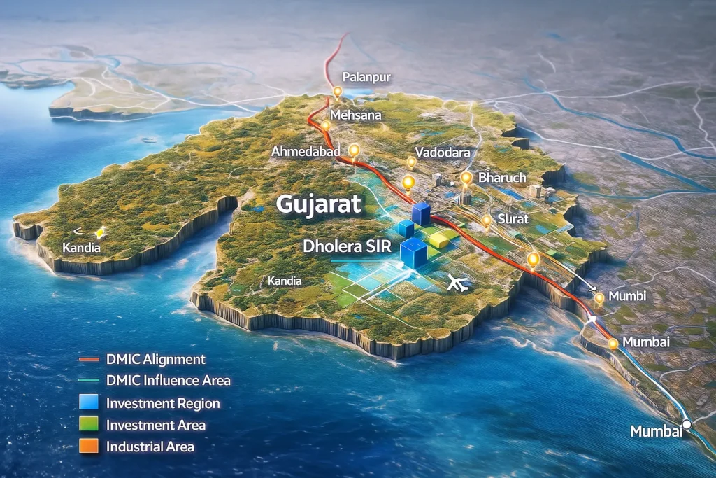
What is the Dholera Gujarat Map?
The Dholera Gujarat Map is the complete macro-level representation of the Dholera Special Investment Region (SIR) inside Gujarat. It shows:
- Entire 920 sq km boundary
- TP zoning structure
- Main highways
- Rail & MRTS routes
- Proposed township zones
- Airport alignment
- Canal system
- Industrial clusters
This map helps you understand how Dholera fits into Gujarat’s overall development structure and its connectivity with Ahmedabad, Bhavnagar, Vadodara, Sanand, Pipli, Bavla, and surrounding cities.
Understanding Dholera’s Road Network Map
The road network of Dholera is one of the strongest elements of its master plan. The city uses:
250-meter Expressway Road
75-meter Major Arterial Roads
55-meter Primary Roads
30-meter Internal Roads
These roads are not just for vehicles — they are embedded with:
Stormwater drainage
Optical fibre ducts
Power ducts
Pedestrian walkways
Greenscapes
Cycling tracks
The map of this grid network helps investors clearly see how accessible their plots or industrial units will be in the future. Because the roads are already constructed in the Activation Area, development is moving faster than most Indian smart cities.
Industrial Zone Maps and Their Importance
Industrial maps of Dholera help buyers understand which industries will come where. The government has allocated land for:
Electronics & semiconductors
EV manufacturing
Defence & aerospace
Logistics & warehousing
Green energy (solar & hydrogen)
Aviation maintenance (MRO)
High-tech manufacturing
The industrial zones are placed near the expressway, airports and logistic hubs for maximum efficiency. This guarantees faster movement of goods and access for global trade.
Maps showing industrial clusters help investors evaluate:
Connectivity
Land-use compatibility
Future value of surrounding plots
Expected industries in nearby areas
This is why most serious buyers study industrial maps before investing.
Dholera Residential Maps – Future Urban Living
Dholera’s residential maps outline the future housing areas, group housing plots, commercial corners, parks, schools and hospitals. These maps help people identify:
Where the future population will grow
Which residential pockets have better connectivity
Where schools, markets and amenities will come
Which areas will be premium vs affordable
Because Dholera is a planned city, residential zones are not mixed randomly with industries. Everything is planned to reduce pollution, avoid congestion and maintain high quality of life.
Dholera Metro/MRTS Route Map – Upcoming Transport Technology
The proposed MRTS (Metro Rail Transit System) route will connect:
Ahmedabad → Dholera Airport → Dholera SIR
This metro map shows:
Station locations
Integration with expressway
Travel time reduction
Future passenger routes
This transport network is designed to support both workers and airport passengers. The MRTS map is one of the most important maps for long-term growth potential.
Why Dholera’s Map Planning is Better Than Other Cities
Compared to normal cities that grow in an unplanned manner, Dholera:
Has pre-designed street grids
Have utilities laid underground
Has water, power and IoT systems integrated
Has zero traffic choke points
Has clear zoning rules
Has a large green buffer
Has a flood-proof and climate-resilient design
This makes Dholera maps extremely detailed, structured and future-ready.
How Investors Use Dholera Maps to Choose Plots
Serious investors use Dholera maps to check:
Distance from the expressway
TP zone density
Proximity to the airport
Future commercial hubs
Type of land (residential/industrial)
Water and power network proximity
Maps reduce risk and increase clarity before buying land.
Dholera Maps for Real Estate Buyers – A Practical Guide
If you are planning to buy land, these maps will help you:
✔ Shortlist the right zone
TP2 for airport-side growth
TP3 for industrial growth
TP1 for residential development
TP4 & TP5 for long-term appreciation
✔ Understand connectivity
Expressway + metro + internal roads define value.
✔ Evaluate future appreciation
Zones near the airport + expressway grow the fastest.
MAP 1 — Dholera Gujarat Map
✔ What This Map Represents
State-level view of Dholera’s geographic location and connectivity.
Map Explanation
This macro map helps you understand the geographical location of Dholera Smart City in Gujarat and why its location is strategic for industries.
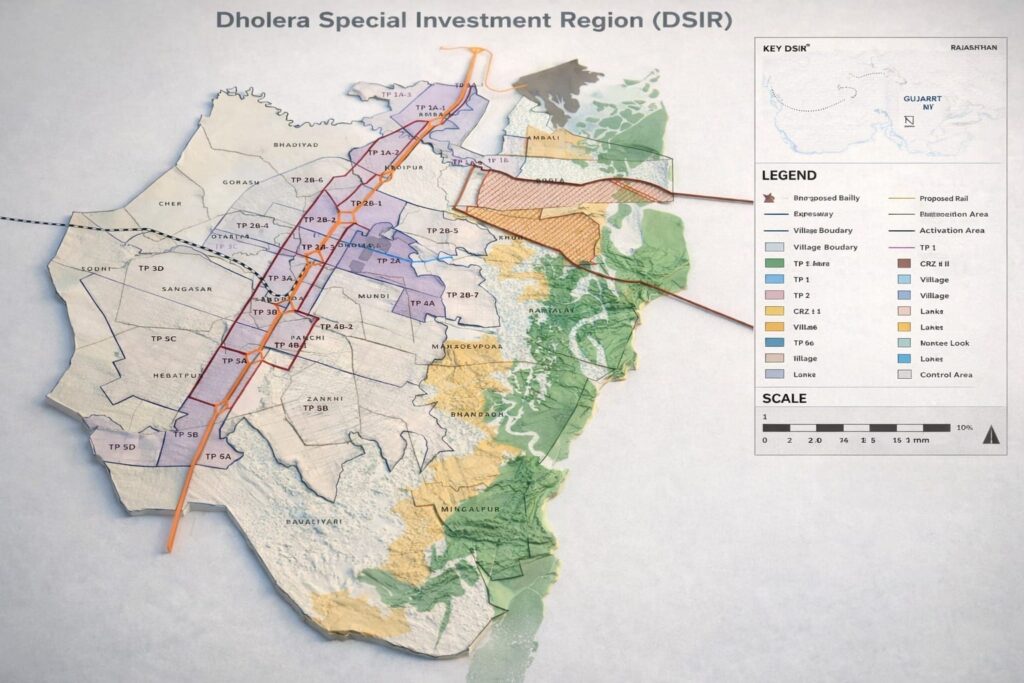
MAP 2 — Dholera SIR Map (TP1–TP6 Zones)
✔ Shows:
TP1 to TP6 zoning
Activation area
ABCD building
Expressway
Industrial & residential blocks
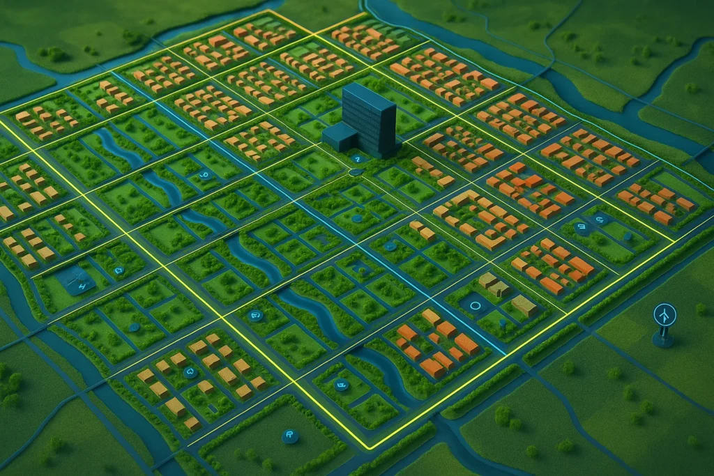
MAP 3 — Dholera City Map (Dholera City Map)
✔ Shows:
Internal 30m, 55m, 75m, 250m roads
City centre
Canal networks
ABCD building
Commercial hubs
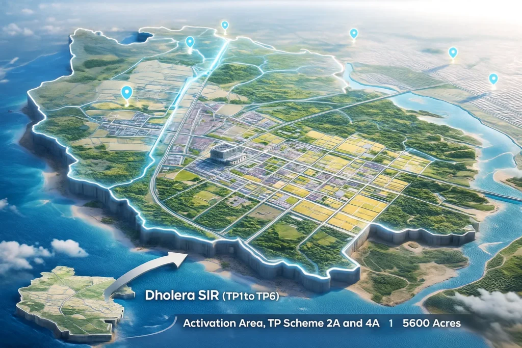
MAP 4 — Activation Area Map
✔ Shows:
Ready infrastructure
Occupancy roads
ABCD building
Utilities network
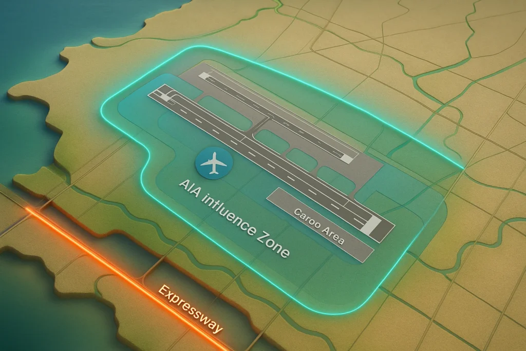
MAP 6 — Dholera International Airport Map
✔ Shows:
Runway
Terminal
Cargo hub
AIA zone
Airport road connectivity
| Feature | Dholera Maps | Other Smart Cities |
|---|---|---|
| Zoning Clarity | High | Medium |
| TP Planning | Detailed | Basic |
| Industrial Focus | Very High | Moderate |
| Map Detail | GIS + Digital Hybrid | Mostly Basic Maps |
Official Dholera Maps: https://dholera.gujarat.gov.in
Nice information
Thank you for your valuable feedback! 😊 We appreciate your support. We’ll continue bringing accurate and up-to-date information about Dholera SIR and its future developments.
Thank you for sharing
Thank you for your appreciation! 😊 We’re glad you found the information useful. Stay connected with DholeraHub for more verified updates, maps, and investment insights about Dholera SIR.
Great site, very informattive,, well planned and deigned
Very good illustration and clearly divided.
Could you advise if it is possible to obtain permission to use thisand incorporate for presentation and education purposes.
Or use parts of the information as i would like to create an interactive version, with additional information of other private commercial projects
Thank you very much for your thoughtful feedback, Amit! 😊 We’re delighted to know you found the website informative and well organized. We’d be happy to answer your questions about Dholera SIR, investment opportunities, infrastructure, or planning. Feel free to share your complete query anytime.